Tropical Storm Erin Expected to Strengthen into 1st Hurricane of Season/ Newslooks/ WASHINGTON/ J. Mansour/ Morning Edition/ Tropical Storm Erin has formed near the Cabo Verde Islands and could become the first hurricane of the 2025 Atlantic season. In the Pacific, Hurricane Henriette has strengthened to Category 1, while remnants of Tropical Storm Ivo have dissipated. Forecasters are watching two additional Atlantic areas for potential development this week.
Tropical Storm Erin Quick Looks
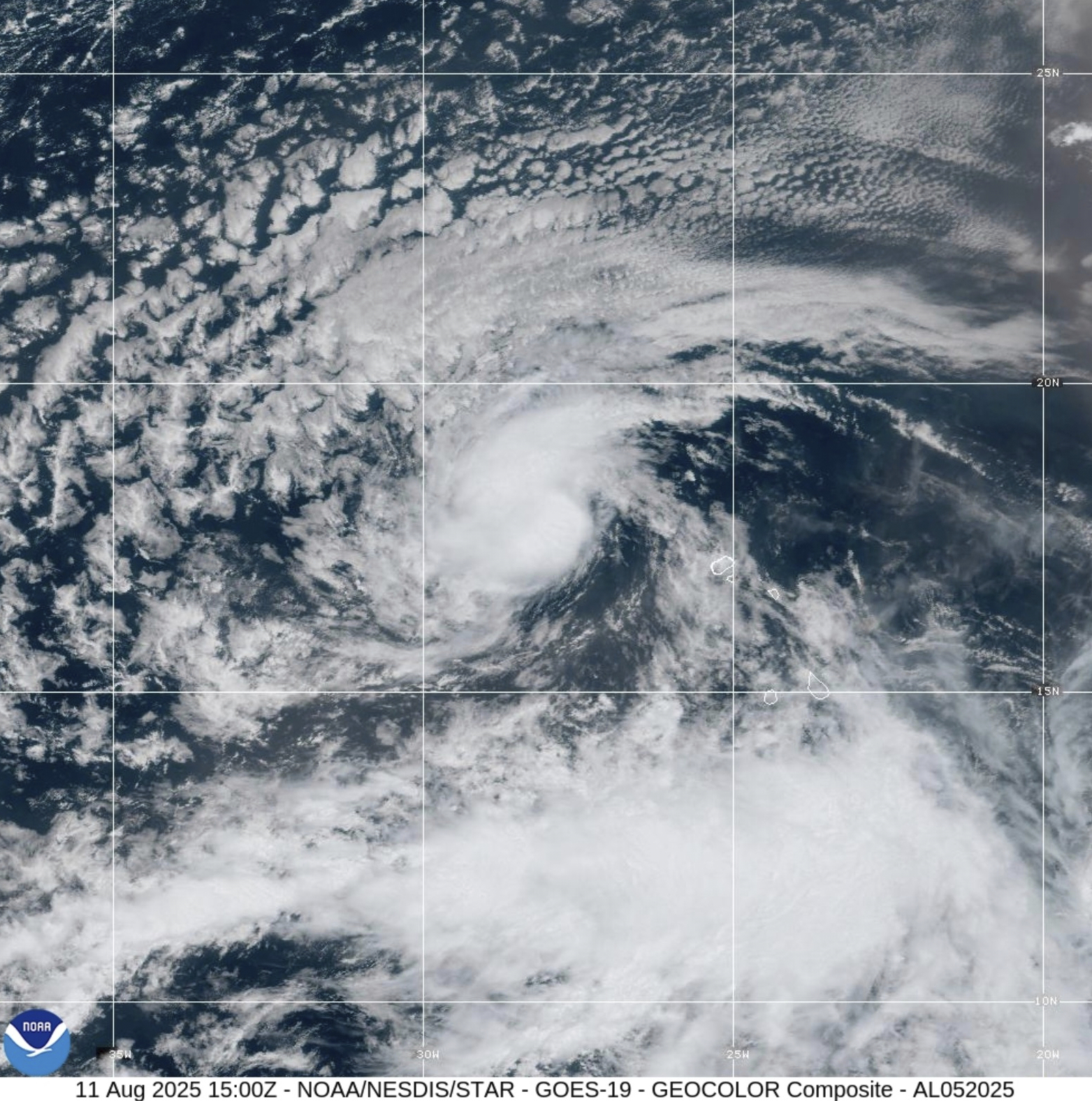
- Erin formed Monday in the eastern Atlantic, 280 miles west-northwest of Cabo Verde.
- Current winds: 45 mph; moving west at 20 mph.
- Expected to strengthen and could become a hurricane by Wednesday.
- Located in the “main development region” for Atlantic hurricanes.
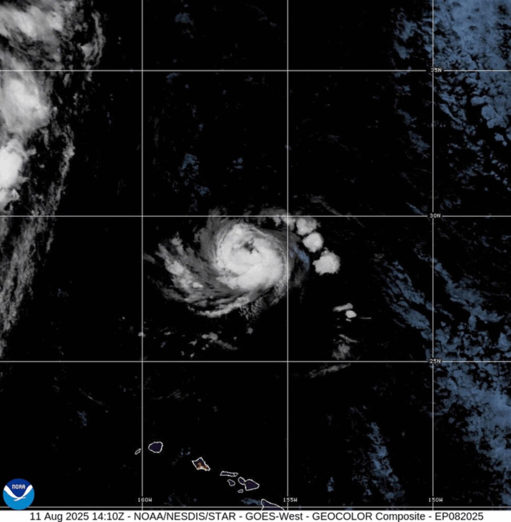
- Hurricane Henriette in the Pacific: 85 mph winds, 525 miles northwest of Honolulu.
- Henriette could strengthen before weakening later in the week.
- Tropical Storm Ivo remnants dissipated west of Baja California, Mexico.
- 2025 Atlantic season has had four named storms so far — no hurricanes yet.
- Sea surface temperatures are above normal, providing fuel for storm intensification.
- Peak Atlantic hurricane season runs from mid-August to mid-October.
Tropical Storm Erin Expected to Strengthen into 1st Hurricane of Season
Deep Look
Tropical Storm Erin became the fifth named storm of the 2025 Atlantic hurricane season on Monday morning, forming just west of Africa’s Cabo Verde Islands. The storm, currently packing sustained winds of 45 mph (72 kph) and moving west at 20 mph (32 kph), is expected to gradually strengthen over the next several days.
The Miami-based National Hurricane Center (NHC) says Erin is traversing the main development region of the Atlantic, a zone stretching from the African coast to the Caribbean that historically produces the basin’s most powerful hurricanes. Warm ocean waters and favorable atmospheric conditions in this region often fuel rapid storm intensification.
Forecasters predict Erin could reach hurricane strength as early as Wednesday evening and potentially intensify into the first major hurricane (Category 3 or higher) of the season by Saturday. The storm’s eventual impact will depend heavily on the position and strength of the Bermuda High — a large area of high pressure that influences storm tracks. This system can steer tropical cyclones toward the Caribbean, the U.S. East Coast, or out to sea.
Sea surface temperatures along Erin’s projected path are significantly warmer than average, although not at the record levels observed in 2023 and 2024. Even so, climate scientists note that ongoing warming from fossil fuel emissions has increased the likelihood of stronger storms. The NHC warns that Erin could undergo rapid intensification once it reaches the warmer waters of the western Atlantic later this week.
Hurricane Henriette in the Pacific
While Erin gathers strength in the Atlantic, Hurricane Henriette continues to churn in the Pacific Ocean, far from any land threat. As of Monday, Henriette was a Category 1 hurricane with sustained winds of 85 mph (137 kph), located about 525 miles (845 km) northwest of Honolulu. The NHC expects Henriette to strengthen slightly before weakening over the next few days as it moves into cooler waters and encounters increased wind shear.
Other Systems in the Tropics
In addition to Erin and Henriette, the NHC reported that the remnants of what was once Tropical Storm Ivo have dissipated in the Pacific, about 615 miles (990 km) west of the southern tip of Mexico’s Baja California peninsula. Ivo no longer poses any threat to land.
Forecasters are also monitoring two other areas of disturbed weather in the Atlantic. Both systems have only a low probability of development as of Monday, but their presence signals that the basin is entering its most active period.
Seasonal Context
So far, the 2025 Atlantic hurricane season has produced four named storms — Andrea, Barry, Chantal, and Dexter — but no hurricanes. Statistically, the first hurricane of the season forms around August 11, meaning Erin’s development is right on schedule. By contrast, the 2024 season had already seen two hurricanes — Beryl and Debby — by this point, with another (Ernesto) forming soon after.
The climatological peak of hurricane season spans from mid-August through mid-October, a window in which the majority of the year’s strongest and most damaging storms occur. The NHC has forecast an above-average season for 2025, citing warm sea surface temperatures and a conducive atmospheric setup.
While it’s still far too early to know Erin’s eventual track or potential land impacts, meteorologists urge residents in hurricane-prone areas to review preparedness plans now. With ocean heat content remaining high and multiple disturbances forming, the Atlantic basin appears poised for an active late summer.