Hurricane Erin Floods NC Highway, Moves Offshore/ Newslooks/ WASHINGTON/ J. Mansour/ Morning Edition/ Hurricane Erin pounded North Carolina’s Outer Banks with flooding, wind, and massive waves before shifting out to sea. The storm forced road closures, beach evacuations, and brought hazardous surf from Florida to New York. Erin remains a Category 2 hurricane with potential to regain strength.
Hurricane Erin Impacts Outer Banks Quick Looks
- Outer Banks flooded as Hurricane Erin skirts the East Coast.
- NC Highway 12 closed due to rising surf and storm surge.
- Homes, ferry routes, and beach access disrupted across the barrier islands.
- Storm remains a Category 2 hurricane, with winds up to 105 mph.
- 500-mile-wide wind field affects states from Florida to New England.
- Forecast warns of rip currents, 18–20-foot waves, and beach erosion.
- Beaches closed in New York, New Jersey, and Delaware.
- Hurricane could intensify again while heading out to sea.
Deep Look: Hurricane Erin Batters Outer Banks With Flooding, Winds, and High Seas
RODANTHE, N.C. (AP) — Hurricane Erin delivered a powerful punch to North Carolina’s Outer Banks on Thursday, unleashing torrential waves, damaging winds, and coastal flooding that swamped key transportation routes and forced residents and tourists into storm survival mode.
As the hurricane gradually pulled away from the East Coast, forecasters warned that Erin could still strengthen, potentially regaining major hurricane status. Though it’s not expected to make direct landfall along the Eastern Seaboard, its outer bands are generating dangerous conditions for hundreds of miles.
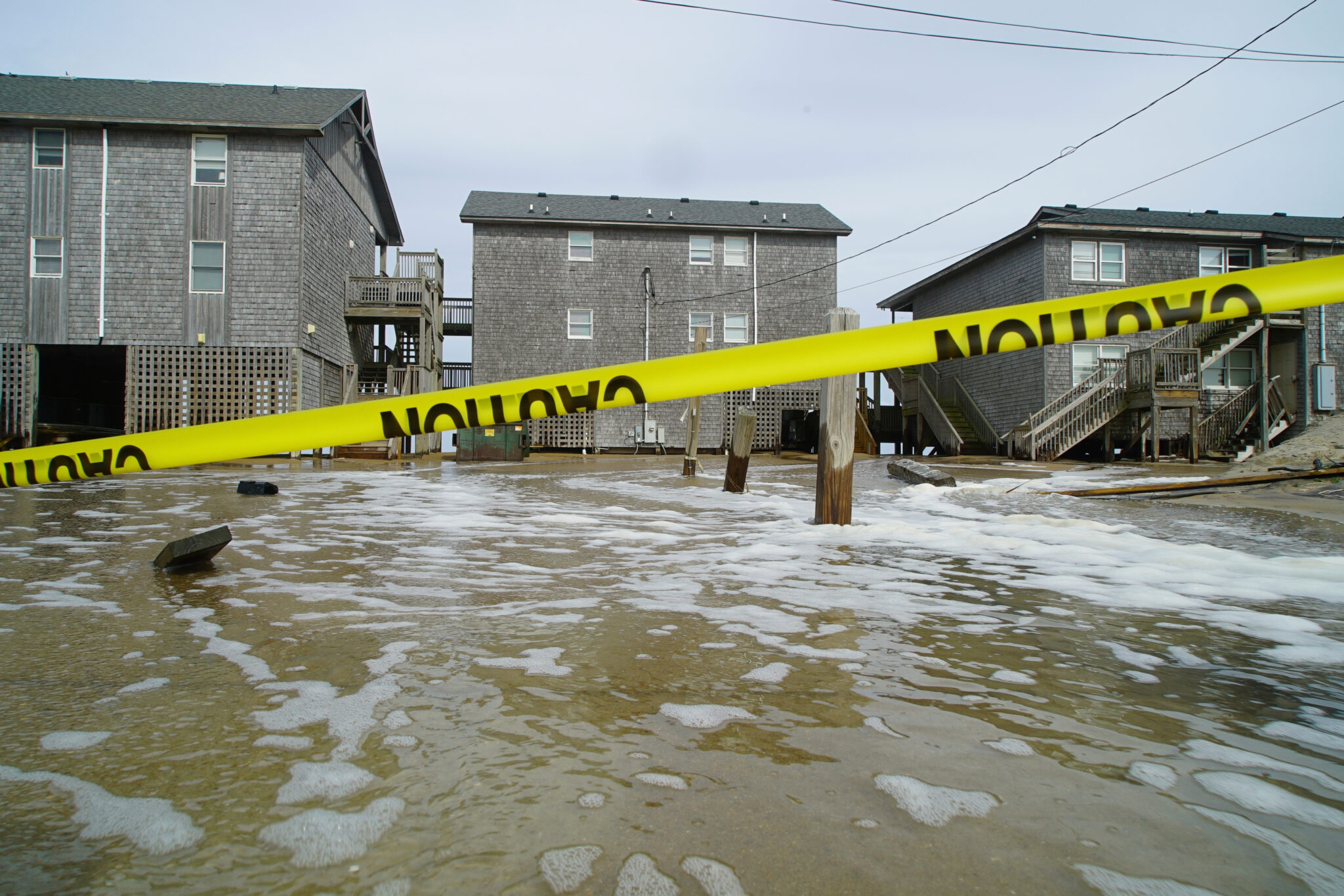
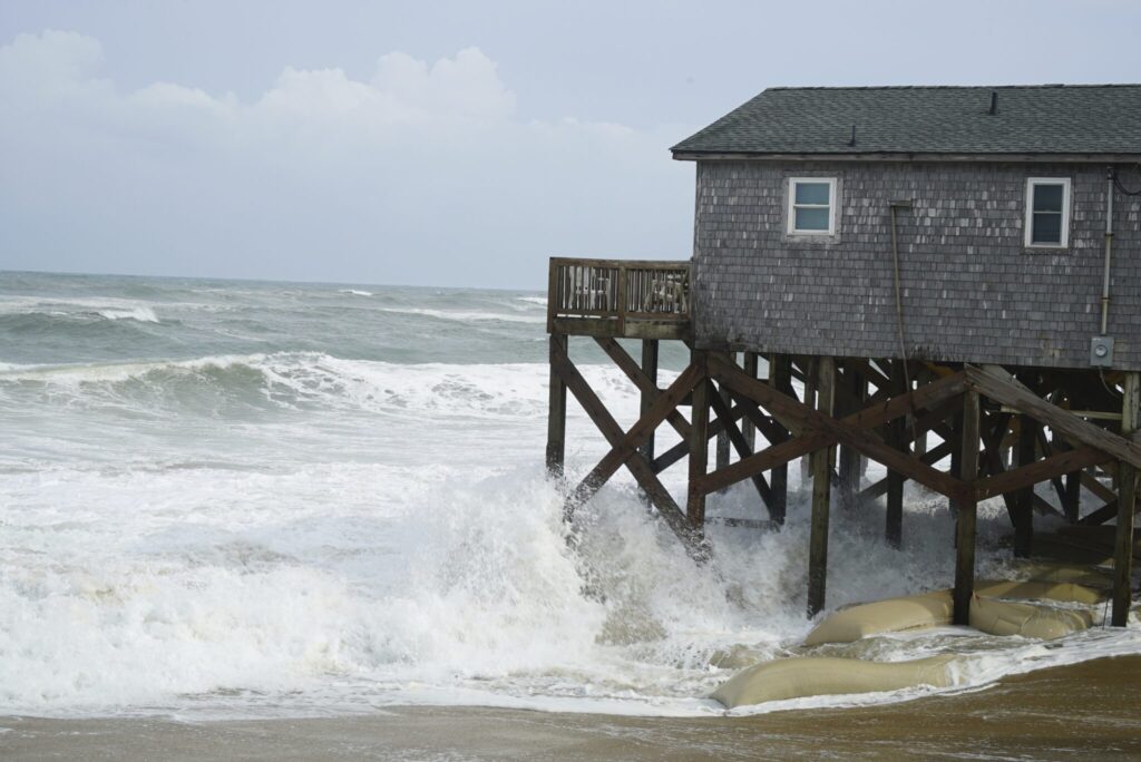
The storm flooded portions of Highway 12, the main artery connecting the thin string of islands along North Carolina’s coast. By Wednesday evening, officials shut down the highway on Hatteras Island, and by Thursday, Ocracoke Island’s ferry access was severed due to rising waters and storm surge.
Melinda Meadows, who manages the Cape Hatteras Motel in Buxton, reported extensive damage to nearby structures.
“A townhouse door was ripped off, walls have been knocked out, and heat pumps have been washed away,” Meadows told WRAL-TV. “It’s the force behind the water.”
A Storm With Massive Reach
Erin, though offshore, remained a Category 2 hurricane Thursday, with sustained winds of 105 mph (165 kph) and a wind field extending over 500 miles (800 kilometers) — roughly the span from New York City to Pittsburgh. At last report, the storm sat about 210 miles (338 kilometers) east of Cape Hatteras, moving northeast at 17 mph (28 kph).
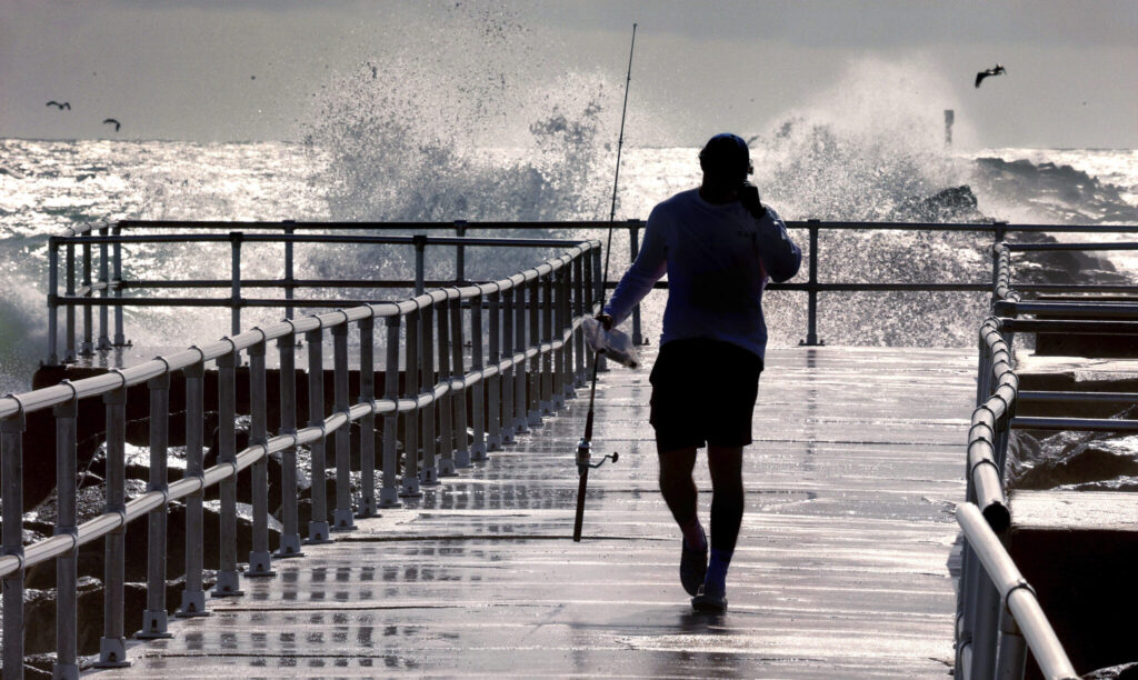
Along Jennette’s Pier in Nags Head, locals gathered to observe nature’s fury. Despite driving rain and crashing surf, David Alan Harvey called it “nature at her best” as he watched 18-foot waves pummel the coast.
“Driving my car is a lot more dangerous than this,” Harvey said from the pier.
Others, like Hatteras resident Daniel Irons, used the storm as an opportunity for bird-watching, while Sebastian Kettner was spotted fishing in the chaos.
Life-Threatening Beach Conditions Across East Coast
The National Hurricane Center warned of life-threatening rip currents and wave action from Florida up to New England. Beaches were closed in New York City, New Jersey, Maryland, and Delaware, while Nantucket Island faced forecasts of waves over 10 feet (3 meters).
Despite warnings, swimmers continued to brave the waters. On Wrightsville Beach, rescuers saved over a dozen people caught in rip currents Tuesday — following more than 80 rescues the day before.
“You can be aware all you want,” said National Weather Service forecaster Bob Oravec, “but it can still be dangerous.”
In addition to human hazards, Erin’s powerful surge put beachfront homes and protective dunes at risk. David Hallac, superintendent of Cape Hatteras National Seashore, said many properties already weakened by erosion could be further damaged.
Local Perspective: Staying Despite the Storm
Many residents, even in the face of mandatory evacuations, chose to remain. Jacob Throne, a surf shop employee on Hatteras Island, recalled past storms.
“I remember taking canoes out of my front yard to get to school,” he said, unconcerned by current conditions.
In Ocracoke, charter cruise operator Rob Temple expressed concern more about road access than the storm itself.
“We probably wouldn’t stay if it was coming directly at us,” Temple said. “My main worry is if Highway 12 washes out and cuts us off.”
Despite rising waters, the Hatteras Island Rescue Squad reported no emergency calls between Wednesday night and Thursday morning.
What’s Next for Erin?
While Erin continues its north-northeast path out to sea, Bermuda has been warned to stay out of the water through at least Friday. Meanwhile, meteorologists are tracking two other potential tropical systems forming far out in the Atlantic — possible future threats to North America.
These storms form near Africa and cross the ocean as “Cape Verde hurricanes,” which are often the most intense and long-lasting systems of the season.
Climate scientists warn that warmer ocean temperatures are intensifying Atlantic hurricanes, making them more likely to rapidly strengthen into devastating storms. Erin’s wide reach and unexpected impact, even without a direct hit, reflect those trends.
“It’s a deceptively dangerous storm,” one forecaster noted. “It doesn’t need to make landfall to disrupt lives.”