Pacific Storm Sparks Deadly Flood Threat in California/ Newslooks/ WASHINGTON/ J. Mansour/ Morning Edition/ A powerful Pacific storm is dumping torrential rain across Southern California, triggering severe flood risks. Evacuation orders are active near wildfire burn scars as rain intensifies over already saturated ground. Authorities warn of life-threatening mudslides, debris flows, and urban flooding across Los Angeles County.
Southern California Flooding Storm – Quick Look
- Storm Origin: Fueled by a powerful Pacific atmospheric river
- Rainfall Impact: Up to 5 inches in mountain/coastal zones
- Flood Risk Level: Level 3 of 4 across much of Los Angeles
- Evacuations Ordered: Palisades, Hurst, Sunset burn scars
- Severe Weather: Potential for hail, strong winds, short-lived tornadoes
- Urban Disruption: Road flooding, power outages, dangerous driving conditions
- High-Risk Zones: Burn scar areas prone to mudslides and debris flows
- Storm Duration: Heaviest rain through Saturday; showers linger into Sunday
Severe Pacific Storm Slams Southern California, Sparking Life-Threatening Flood Risks
Deep Look
LOS ANGELES — A powerful Pacific storm is drenching Southern California this weekend, unleashing torrential rainfall, flash flooding, and triggering fears of dangerous mudslides and debris flows—especially in wildfire burn scar zones across the Los Angeles region.
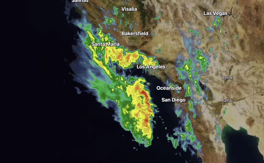
As of Saturday morning, radar imagery showed widespread rain across coastal Southern California with heavier downpours expected throughout the day. The National Weather Service (NWS) has issued flood watches for much of the area through Saturday evening, warning that the storm poses life-threatening hazards, particularly in locations scarred by recent wildfires.
Key Threat Areas and Warnings
- Evacuation Orders Issued: Los Angeles Mayor Karen Bass announced mandatory evacuations for at-risk areas near the Palisades, Hurst, and Sunset burn scars.
- High Flood Risk: Much of the Los Angeles basin is under a Level 3 of 4 risk for flash flooding, per the Weather Prediction Center.
- Debris Flow Danger: The NWS has warned of “significant” mudslide threats in additional areas, including the Eaton and Bridge burn scars.
- Extended Storm Timeline: Rain began Thursday in Northern California and is expected to continue into Sunday, with the heaviest precipitation occurring late Friday through Saturday night.
The Storm’s Impact So Far
This weather system originated in the Pacific and began pounding Northern and Central California earlier in the week. Coastal areas received 1 to 2 inches of rain by Friday morning, with 3 to 5 inches falling over the coastal mountain ranges.
In San Francisco, nearly 1.5 inches of rain fell Thursday—roughly 75% of the city’s average rainfall for the entire month of November. The storm marks the seasonal transition into California’s wetter months, which typically peak from December to February.
What Makes This Storm So Dangerous?
Meteorologists point to several compounding factors increasing the danger of this storm:
1. Atmospheric River Enhancing Rainfall
This storm system is being fueled by an atmospheric river—a narrow corridor of concentrated moisture from the Pacific Ocean. This phenomenon significantly boosts rainfall rates and overall storm intensity.
- Rainfall rates could exceed 1 inch per hour in some areas on Saturday, according to forecasts.
2. Already Saturated Ground
Southern California experienced soaking rain on Friday, leaving the ground unable to absorb additional water. With the soil oversaturated, even moderate rainfall can quickly turn into flash flooding.
3. Severe Weather Potential
Embedded within the heavier rainfall bands are isolated thunderstorms. The NWS has warned that some of these storms could deliver:
- Damaging wind gusts
- Small hail
- Brief tornadoes, particularly overnight into Saturday morning
Burn Scar Regions at High Risk
Areas previously scorched by wildfires are facing extreme susceptibility to mudslides and debris flows. These include not only the zones under mandatory evacuation but also other burn sites across the region.
Why Burn Scars Are Vulnerable:
- Wildfires destroy vegetation that would otherwise absorb rainfall.
- Intense heat creates a hydrophobic (water-repellent) layer in the soil, leading to rapid runoff.
- Without plant roots to hold soil in place, mudslides and debris flows can occur suddenly and violently, even with moderate rainfall.
Weather meteorologists warned that many of these zones “could give way without notice,” putting homes, roads, and lives in danger.
Transportation and Infrastructure Impact
Heavy rainfall has already disrupted roadways across California, with scenes of cars submerged in water, including parts of Highway 880 in Oakland, earlier this week.
With more intense rain on the way, Southern California residents should brace for:
- Road closures and delays
- Fallen trees and power outages
- Urban flooding, especially in low-lying intersections and poorly drained neighborhoods
Authorities are urging residents to stay off the roads unless absolutely necessary and to never drive through flooded areas.
When Will the Rain End?
The heaviest rainfall is expected to taper off late Saturday night, but scattered showers will continue into Sunday.
Because the ground will remain saturated, even light rainfall can trigger:
- Additional minor flooding
- Muddy road conditions
- Extended risks in burn scar zones
The NWS says it will only take a fraction of Saturday’s rainfall to cause new issues on Sunday, especially in slow-draining or low-lying areas.
Official Guidance & Safety Tips
Residents in the affected areas are strongly advised to:
- Follow evacuation orders immediately
- Avoid driving through flooded roads
- Stay updated through official weather alerts via NOAA, NWS, and local agencies
- Prepare emergency kits in case of power outages or forced relocation
- Check on elderly neighbors or those with limited mobility
What’s Next for California?
This storm is the latest in a series of increasingly intense weather systems to impact the West Coast, part of a larger climate trend experts are closely monitoring.
With El Niño conditions developing in the Pacific, meteorologists anticipate a wetter-than-average winter for California, raising concerns about future flooding, landslides, and water management challenges in 2025–2026.