
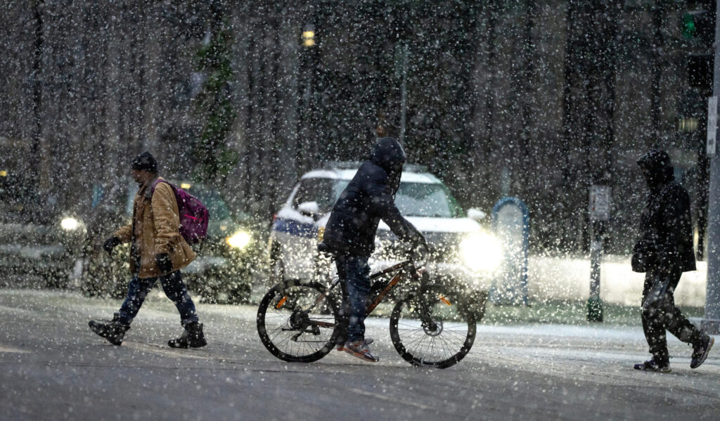
Bomb Cyclone Brings Blizzard, Power Loss Across States/ Newslooks/ WASHINGTON/ J. Mansour/ morning Edition/ A powerful winter storm swept across the Midwest, bringing blizzard conditions, dangerously low wind chills, and widespread power outages. The system intensified into a bomb cyclone, triggering flight delays, lake-effect snow, and even a tornado in Illinois. Severe weather extended from California to the Northeast, disrupting holiday travel and utilities nationwide.

Midwest Blizzard Conditions + Quick Looks
- Powerful winter storm causes whiteout blizzard conditions in the Midwest
- Wind chills plunge to -30°F across North Dakota and Minnesota
- Over 350,000 lose power; Michigan hardest hit
- Bomb cyclone classification confirmed by rapid pressure drop
- EF1 tornado strikes Illinois, causing structural damage
- Lake-effect snow, high winds batter Great Lakes and Northeast
- Santa Ana winds heighten tree-fall risks in Southern California
- Flight delays exceed 3,500, with 600+ cancellations
- New England sees freezing rain, raising power line concerns
- Sharp cold front causes rapid temperature drop in Southern U.S.
Bomb Cyclone Brings Blizzard, Power Loss Across States
Deep Look
A ferocious winter storm barreled through the Upper Midwest on Monday, unleashing blizzard conditions, life-threatening wind chills, and widespread disruptions across the United States. The National Weather Service warned of whiteout conditions and near-impossible travel across the northern Plains as the storm strengthened over the weekend.
Meteorologists from the Weather Prediction Center described the weather system as unusually intense, even for a region well-acquainted with harsh winters. Heavy snow and strong winds swept through Michigan and surrounding Great Lakes areas, while freezing rain coated parts of New England.
The storm intensified rapidly as it moved from the Midwest to the Great Lakes, meeting the criteria for a bomb cyclone, a meteorological term used when atmospheric pressure drops drastically over a short period. Meteorologist Cody Snell explained that lower central pressure equals a stronger storm, and this system saw a significant plunge.
With the passage of an arctic cold front, central U.S. states saw dramatic temperature drops — up to 50°F in some areas. These conditions triggered wind chills as low as -30°F in parts of North Dakota and Minnesota, heightening the risk for frostbite and hypothermia.
In Michigan’s Upper Peninsula, snowfall reached 19 to 24 inches, and although more snow is expected, it is likely to be lighter than the initial surge. Lake-effect snow and intense wind gusts continue to pose hazards across New York, Michigan, and Ohio, with some areas bracing for 1 to 3 feet of snow and winds up to 75 mph.
Meanwhile, Southern California faced its own weather threats. Santa Ana winds in Los Angeles and Ventura counties increased the risk of falling trees due to recently saturated soil. These strong winds followed what meteorologists are calling one of the wettest Christmas periods in recent years.
Across the country, severe disruptions followed the storm’s path. Over 350,000 customers lost power Monday morning, with Michigan bearing the brunt. Airports were overwhelmed, as more than 3,500 flights were delayed and over 600 were canceled due to dangerous weather conditions and limited visibility.
Severe weather extended beyond snow and wind. An EF1 tornado with estimated winds of 98 mph touched down in Tazewell County, Illinois, on Sunday morning. The storm destroyed two outbuildings, toppled trees, and snapped power poles. Additional storm damage was being evaluated Monday in Macon County, where severe thunderstorms had also struck.
Blizzard warnings were issued across much of Michigan’s Upper Peninsula, with wind gusts expected to reach up to 60 mph near Lake Superior. Northern Iowa also experienced blizzard conditions, making travel treacherous or impossible in certain areas.
In New England, freezing rain created further complications, particularly in northern New York, Vermont, New Hampshire, and Maine. Ice buildup on power lines and trees posed a secondary threat as the system moved eastward.
The South, which had been experiencing unseasonably warm temperatures, saw an abrupt shift as the cold front pushed through. Meteorologists warned of severe thunderstorms signaling the front’s arrival, followed by a sharp drop in temperatures and gusty north winds. These colder conditions are expected to persist into the new year.
The storm’s growing intensity has been attributed to the collision of frigid Arctic air from Canada and lingering warm air in the southern U.S., creating a volatile environment for rapid storm development. This dynamic pattern is expected to bring further disruptions as the system continues to move along the East Coast.