FEMA Removed Camp Mystic From Flood Maps/ Newslooks/ WASHINGTON/ J. Mansour/ Morning Edition/ FEMA granted multiple appeals that removed Camp Mystic buildings from flood hazard maps, reducing oversight as the Texas camp expanded in a known flood zone. The exemptions preceded a catastrophic flood that killed 27 people. Experts question why critical flood protections were lifted for a site housing hundreds of children.
FEMA Removed Camp Mystic From Flood Maps: Quick Looks
- Appeals Granted: FEMA excluded Camp Mystic buildings from flood maps.
- Tragic Flood: Camp Mystic flood killed 27 campers and staff.
- Historic Flood Plain: Camp located along flood-prone Guadalupe River.
- Expansion Allowed: Camp expanded facilities despite flood risks.
- Insurance Implications: Map changes reduced insurance and regulation costs.
- Experts Alarmed: Scholars criticize FEMA’s decision for high-risk site.
- Data Discrepancies: Private models show greater flood risks than FEMA’s maps.
- Equity Concerns: Wealthier property owners more likely to win map changes.
FEMA Removed Camp Mystic From Flood Maps
Deep Look
Federal regulators repeatedly approved appeals to remove dozens of Camp Mystic buildings from the federal 100-year flood map, reducing oversight for the prestigious girls’ camp even as it operated and expanded within a hazardous flood plain, an Associated Press investigation has revealed.
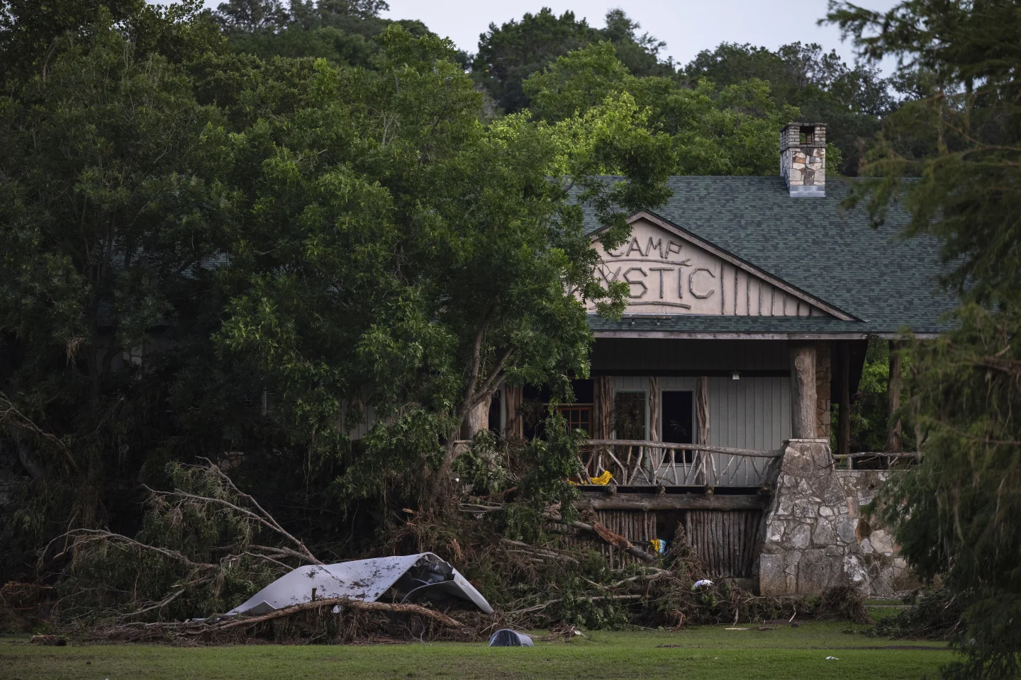
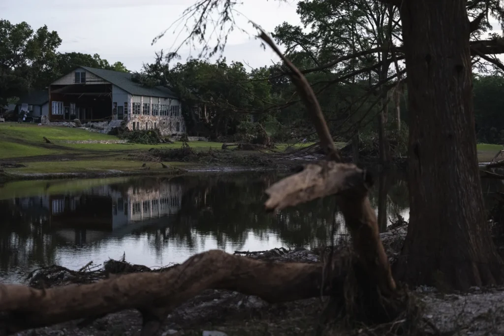
The FEMA decisions, while legal and often pursued by property owners seeking fewer restrictions, have come under intense scrutiny in the wake of last week’s catastrophic flood that swept through Camp Mystic before dawn on July 4, killing at least 27 campers, counselors, and longtime owner Dick Eastland.
A Site Long Known For Flood Danger
Camp Mystic sits in a low-lying stretch of land along the Guadalupe River, within Texas’ notorious “flash flood alley,” an area frequently hammered by intense rainstorms that funnel torrents of water through hill country valleys.
In 2011, the Federal Emergency Management Agency designated the camp’s location as part of a “Special Flood Hazard Area” on Kerr County’s National Flood Insurance map. Such a classification carries significant consequences: property owners must carry flood insurance and face stricter rules governing future construction or expansion.
A “100-year flood zone” signifies an area with a 1% annual chance of flooding. Yet experts say the July 4 flood far exceeded that benchmark, moving so swiftly in the dead of night that it overwhelmed any possible warning systems and left campers with little chance to escape.
FEMA Quietly Removed Buildings
Records show Camp Mystic fought to remove its properties from those stringent rules.
In 2013, FEMA granted the camp’s first major appeal, revising its map to exclude 15 buildings on the original Camp Mystic Guadalupe campus. These structures, some over 99 years old, were among those devastated by the July flood.
More appeals followed. Between 2019 and 2020, FEMA approved removing an additional 15 buildings from flood hazard designation. These newer structures were part of Camp Mystic Cypress Lake, a sister campus built during a sweeping expansion that included new cabins, a chapel, an archery range, and other amenities. While Cypress Lake suffered damage during the flood, it reportedly fared better than the older Guadalupe campus.
“It’s a mystery to me why they weren’t taking proactive steps to move structures away from the risk, let alone challenging what seems like a very reasonable map,” said Sarah Pralle, a Syracuse University associate professor who has extensively studied FEMA’s flood mapping process. “Particularly disturbing” is that a site responsible for the safety of so many children received exemptions from basic flood regulation, she said.
Possible Motives for FEMA Appeals
Experts suspect Camp Mystic’s push for map changes was motivated by economics. Remaining on the flood map would have meant expensive flood insurance premiums and potentially costly design requirements for new construction projects. Exclusion from the hazard zone reduced regulatory hurdles and allowed the camp to expand more freely.
“Communities and property owners have successfully used appeals to shield specific properties from regulation,” Pralle explained. Her research shows that FEMA approves around 90% of such amendment requests.
Records indicate that some of Camp Mystic’s exempted properties sat just two feet outside the designated flood plain—an extremely narrow margin that leaves little room for error when it comes to flooding forecasts.
Expansion Despite Warnings
Even after FEMA’s amendments, parts of Camp Mystic remained in designated flood zones. FEMA warned that any future construction in those areas would be subject to flood plain management regulations.
Yet county officials permitted the camp not only to continue operations but to pursue aggressive growth. Driven by what owners Dick and Tweety Eastland called the “tremendous success” of the original camp, Mystic expanded to include the Cypress Lake campus in 2020.
Records show that as of July 2—just two days before disaster struck—the camp was hosting 557 campers and over 100 staff across its two locations.
Flood Models Tell a Different Story
Data from First Street, a climate risk data firm, suggests FEMA’s flood maps significantly understate the true danger at Camp Mystic’s sites.
According to Jeremy Porter, First Street’s head of climate implications, the FEMA maps often fail to account for localized hazards like flash floods triggered by intense rainfall in small watersheds.
“FEMA’s flood insurance map underestimates flood risks because it doesn’t capture the impact of heavy precipitation on small waterways,” Porter said.
First Street’s models show almost the entirety of Camp Mystic Guadalupe faces flooding during a 100-year storm, contradicting FEMA’s more conservative mapping. The Cypress Lake campus, while farther from the river, is still near Cypress Creek—a waterway that FEMA’s maps don’t consider high risk, but First Street’s data suggests otherwise.
FEMA responded in a statement, noting that its maps provide a “snapshot in time” and are designed to show minimum standards for floodplain management. The agency acknowledged that maps “are not predictions of where it will flood, and they don’t show where it has flooded before.”
The Politics and Inequities of Flood Mapping
Pralle and other researchers argue that FEMA’s appeals process may inadvertently favor wealthier property owners or those with resources to hire engineers and lawyers to navigate the complex bureaucracy. A 2021 study she co-authored found that FEMA map amendments were more common in higher-value neighborhoods and areas with predominantly white populations.
“There’s a real equity issue here,” Pralle said. “Communities with fewer resources are left more vulnerable because they can’t challenge flood maps as easily.”
Local Officials Defend Decisions
While questions swirl about regulatory failures, local officials insist they acted based on the best available data. Chris Steubing, executive director of the Texas Floodplain Management Association, said the rainfall that struck Kerr County was unprecedented in scale.
“Mother Nature set a new standard,” Steubing said. “You could have built things 2 feet higher, 3 feet higher, and they still might have gotten taken down.”
Nonetheless, for grieving families and safety advocates, FEMA’s repeated willingness to erase flood hazards from Camp Mystic’s maps raises painful questions about how regulatory decisions might have contributed to the deadly consequences of this summer’s historic flood.