Hurricane Barbara Strengthens, Nears Mexico’s Pacific Coastline \ Newslooks \ Washington DC \ Mary Sidiqi \ Evening Edition \ Hurricane Barbara intensified Monday, becoming the first hurricane of the eastern Pacific season as it moved away from Mexico’s coast. The storm is expected to weaken by nightfall but could still bring dangerous surf and flooding. Meanwhile, Tropical Storm Cosme is nearing hurricane strength offshore.
Quick Looks
- Hurricane Barbara became the first named hurricane of the 2025 Pacific season.
- Located 175 miles from Manzanillo, Mexico, with 75 mph sustained winds.
- Swells expected to create hazardous surf and rip currents along the southwest coast.
- Heavy rains may cause flooding in Guerrero, Michoacán, Colima, and Jalisco.
- The storm is moving northwest at 10 mph and expected to weaken overnight.
- No coastal watches or warnings issued yet by Mexican authorities.
- Tropical Storm Cosme strengthened offshore with 70 mph winds.
- Cosme remains far from land but could reach hurricane strength briefly.
Deep Look
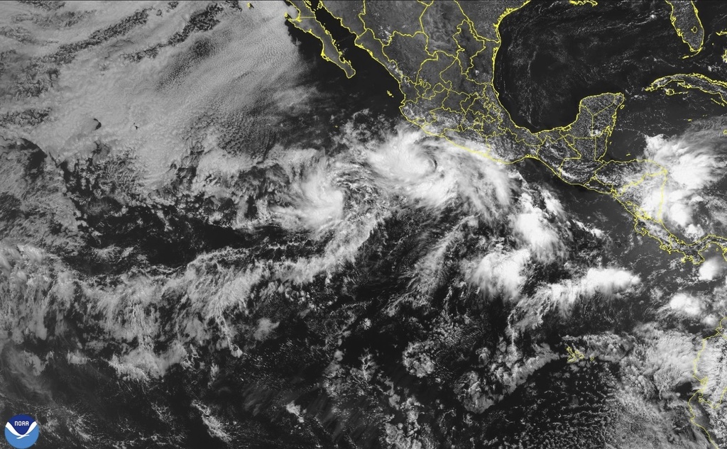
The 2025 eastern Pacific hurricane season opened with intensity on Monday, as Hurricane Barbara rapidly strengthened from a tropical storm and churned northwestward away from the Mexican coastline. Though it remains over open water, Barbara’s effects are already being felt along portions of southwestern Mexico’s shoreline. The storm represents not only the first hurricane of the season, but also a reminder of the unpredictable and growing power of tropical systems in a warming climate.
According to the National Hurricane Center (NHC) in Miami, Hurricane Barbara reached Category 1 strength early Monday with maximum sustained winds of 75 mph (120 km/h). At the time of the latest advisory, the storm’s center was positioned approximately 175 miles (280 kilometers) west-southwest of Manzanillo, Mexico, moving northwest at 10 mph (17 km/h).
Despite being far offshore, Barbara is already impacting coastal weather conditions. The NHC warned that dangerous swells generated by the storm will affect large stretches of the Mexican Pacific coast for several days. These swells are forecast to produce life-threatening surf and strong rip currents, especially across the coastal states of Guerrero, Michoacán, Colima, and Jalisco—regions that frequently face the brunt of early-season storms.
While no coastal warnings or watches were in effect as of Monday afternoon, Mexican authorities and emergency officials remain on high alert. Rain bands from Barbara are expected to bring localized heavy rainfall, raising concerns about flooding in low-lying coastal areas and urban zones with poor drainage. Even in the absence of a direct landfall, such peripheral impacts are often enough to cause significant disruption in vulnerable areas.
The track forecast suggests that Barbara will continue northwest into cooler ocean waters, which will likely lead to gradual weakening by Monday night or early Tuesday. The storm is not expected to make landfall, but its outer bands may brush past the southern Baja California Peninsula, prompting precautionary preparations in that region.
Barbara’s quick intensification and organized structure align with patterns seen more frequently in recent hurricane seasons. Meteorologists have noted a trend of rapid intensification events due to above-average sea surface temperatures in the eastern Pacific. Warm water fuels tropical cyclones, and with oceans warming globally, the Pacific basin has seen a noticeable uptick in early-season storm activity.
Adding to the Pacific drama is Tropical Storm Cosme, located much farther out at sea. By Monday afternoon, Cosme was positioned roughly 605 miles (975 kilometers) south-southwest of the southern tip of Baja California, with sustained winds of 70 mph (100 km/h). The storm, while still officially below hurricane strength, was projected to approach the threshold by Monday evening before beginning a northeasterly turn and accelerating through midweek.
Unlike Barbara, Cosme poses no immediate threat to land. Its projected track keeps it well offshore, but meteorologists continue to monitor the storm closely for any shifts in direction or speed. While not expected to directly impact Mexico, Cosme serves as another signal that the Pacific storm season is picking up earlier than usual.
Both Barbara and Cosme arrive in a broader climate context that’s reshaping how coastal communities and forecasters approach storm seasons. The eastern Pacific hurricane season officially runs from May 15 to November 30, but storms forming earlier or with more strength are becoming increasingly common. According to climate researchers, warmer sea temperatures and altered atmospheric patterns tied to El Niño conditions may contribute to more frequent and intense Pacific storms in 2025.
Emergency management agencies in Mexico are urging residents along the southwestern coast to stay vigilant. Even without landfall, rising tides, high surf, flash floods, and gusty winds are among the secondary impacts that can cause damage or loss of life. Local officials in Michoacán and Colima have issued advisories warning citizens to avoid beaches and to secure property in flood-prone areas.
Looking ahead, meteorologists expect Barbara to weaken gradually as it moves away from the Mexican coast, but its presence so early in the season sends a clear message: the 2025 hurricane season may be more active and hazardous than average. Cosme, although farther out, will also be watched closely as it progresses into midweek.
The NHC and Mexican meteorological services will continue issuing updates as both systems evolve. For residents in storm-sensitive areas, this early-season activity underscores the importance of having a plan in place before peak hurricane months arrive.
In a region where infrastructure varies widely and evacuation routes can be limited, advance notice and early action often mean the difference between resilience and tragedy. Barbara may be the first named hurricane of 2025, but it likely won’t be the last—and preparedness will remain key as the season unfolds.