Hurricane Erin Becomes Atlantic’s First Hurricane of 2025/ Newslooks/ WASHINGTON/ J. Mansour/ Morning Edition/ Hurricane Erin has officially become the first hurricane of the 2025 Atlantic season, now moving west-northwest across the open Atlantic. The storm could intensify into a major hurricane as it nears the northeastern Caribbean this weekend. While direct landfall is unlikely, Erin may bring dangerous surf, wind, and rain to nearby islands.

Hurricane Erin Development Quick Looks
- Status: Erin becomes first hurricane of the 2025 season
- Current Strength: Category 1, 75 mph sustained winds
- Location: Over 400 miles east of the Leeward Islands
- Forecast: Expected to strengthen into a Category 3 or 4
- Tropical Watches: In effect for parts of the northern Leeward Islands
- Caribbean Impact: Rough seas, heavy rain, rip currents likely
- Bermuda Risk: Too early to determine direct impact
- US Threat: Expected to stay offshore, but surf may increase
- Steering Factors: Bermuda High and sea temperatures influence path
- Other Systems: Gulf disturbance could bring rain to Texas and Mexico

Deep Look: Hurricane Erin Becomes First of 2025 Atlantic Season, Could Strengthen Rapidly
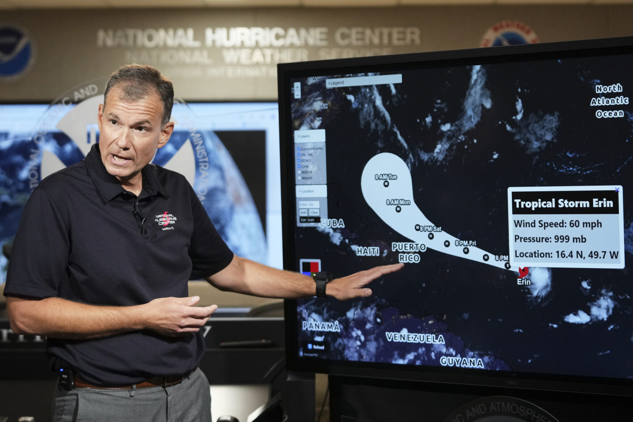
ATLANTIC OCEAN – August 15, 2025 — After weeks of viral speculation and several false starts to the Atlantic hurricane season, Hurricane Erin has officially formed. The National Hurricane Center (NHC) confirmed Friday morning that Erin reached Category 1 strength with sustained winds of 75 mph, making it the first hurricane of the 2025 Atlantic season.
Erin is currently located more than 400 miles east of the Leeward Islands, tracking west-northwest as it slowly intensifies over unusually warm Atlantic waters. Forecasters say the storm is poised to strengthen significantly over the next few days and could become a Category 3 major hurricane by late Saturday, possibly reaching Category 4 strength by Sunday night or early Monday.
Slightly Behind Schedule, But Rapid Intensification Likely
Historically, the first Atlantic hurricane of the season typically forms around August 11, but Erin’s formation, though a few days late, comes as no surprise. Previous systems—Andrea, Barry, Chantal, and Dexter—had remained tropical storms or failed to fully organize. In contrast, 2024 had already seen three hurricanes by this point.
Now, all eyes are on Erin’s path, as the storm threatens to stir up rough surf, gusty winds, and localized flooding across parts of the northeastern Caribbean, especially Puerto Rico, the Virgin Islands, and the northern Leeward Islands.
Watches in Effect as Storm Edges Closer
Tropical storm watches are currently in place for parts of the northern Leeward Islands. These may soon be upgraded to tropical storm warnings if conditions are expected within 24 hours. While direct landfall is not currently forecast, a small shift in Erin’s trajectory could bring more severe impacts to island communities.
Even if it stays offshore, Erin is expected to bring heavy rainfall, strong gusts, high surf, and dangerous rip currents through the weekend. Flash flooding or mudslides are possible in mountainous terrain, depending on how close the storm gets.
Uncertainty Remains for Bermuda and U.S. Coast
Forecasters say it’s too early to determine whether Bermuda could experience direct impacts. Erin’s path is expected to shift northward early next week, and the United States East Coast is currently outside the projected cone. However, forecasters caution that long-range hurricane tracks are never certain.
Even if Erin does remain offshore, it will likely send strong waves and dangerous rip currents toward the U.S. Atlantic coastline by mid-next week.
Storm Track Depends on Strength and Atmospheric Steering
The storm’s strength in the next 48 hours will play a crucial role in determining its eventual path. As Erin intensifies, it will develop taller storm clouds capable of reaching higher into the atmosphere. That vertical growth would allow the storm to catch stronger upper-level winds, steering it more northward.
If Erin strengthens quickly, it may get pulled northward by the Bermuda High, a dominant high-pressure system in the Atlantic that often acts as a steering wheel for tropical systems. A rapid intensification phase could also allow the storm to bend away from land more quickly.
However, if Erin strengthens more slowly, it could remain trapped in lower-level trade winds, continuing a more westerly track and increasing the potential threat to the Caribbean.
Atlantic Activity Heating Up
Forecasters have long projected an above-average Atlantic hurricane season, and Erin may only be the beginning. The peak of hurricane season traditionally runs from mid-August to mid-October, and with ocean temperatures running well above normal, more storms are likely.
One system already bears watching: A cluster of showers and thunderstorms in the southern Gulf of Mexico could organize into a tropical depression before moving inland. The National Hurricane Center gives it a medium chance of development, but the window for intensification is short.
Gulf System Could Bring Rain to Texas and Mexico
The system in the southern Gulf of Mexico is forecast to move inland by Friday night, likely impacting northeastern Mexico and southern Texas. Regardless of development, it will bring heavy rainfall, with the Weather Prediction Center issuing a Level 2 of 4 risk for flooding rain in far southern Texas and a Level 1 risk for parts of Louisiana and Mississippi.
The National Weather Service in Brownsville, Texas, has warned that low-lying and poorly drained areas may experience localized flooding. Tropical systems in this region can intensify rapidly, so communities are urged to stay alert.