Two Tropical Storms May Shield Carolinas from Damage/ Newslooks/ WASHINGTON/ J. Mansour/ Morning Edition/ Two tropical storm systems in the Atlantic could interact in a rare phenomenon that may spare the Carolinas from heavy rain and flooding. Developing Tropical Depression Imelda threatens the region, while powerful Hurricane Humberto could tug it away from shore. Scientists say the outcome depends on Humberto’s track and intensity.
Tropical Storms Near Carolinas Quick Looks
- Developing tropical depression (likely Imelda) heading toward Carolinas
- Could bring damaging rainfall if it stalls inland
- Major Hurricane Humberto may interact with the storm system
- Interactions include merging, weakening, or redirection of Imelda
- Rare Fujiwhara Effect could cause storms to “dance” around each other
- NOAA sending extra aircraft missions to monitor conditions
- Most likely: Humberto pulls Imelda eastward, away from Carolinas
- Carolina residents urged to stay alert for flooding risks
- Experts stress outcome depends on Humberto’s westward movement
- Such storm interactions are rare in the Atlantic basin
Deep Look: Twin Tropical Storm Systems May Shield Carolinas from Flooding Threat
NEW YORK — September 27, 2025
Meteorologists are closely watching two tropical weather systems in the Atlantic that could interact in a highly unusual way, potentially sparing the Carolinas from destructive rainfall and flooding. The unfolding scenario hinges on whether a developing depression near Cuba — expected to become Tropical Storm Imelda — collides, merges, or is redirected by the much larger Hurricane Humberto.
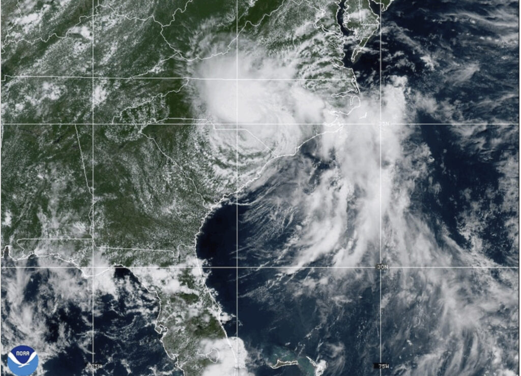
Developing Depression Targets Carolinas
The National Hurricane Center confirmed Friday that the developing storm, still unnamed but tracking toward the South Carolina–North Carolina border, carries the risk of damaging, prolonged rainfall if it lingers after landfall. “People need to pay attention,” said NHC Director Michael Brennan, warning residents to remain vigilant for flood threats.
Forecasters expect the storm to head north, bringing it dangerously close to the U.S. coastline early next week. If it strengthens and stalls, the system could deliver heavy downpours, flash flooding, and infrastructure strain.
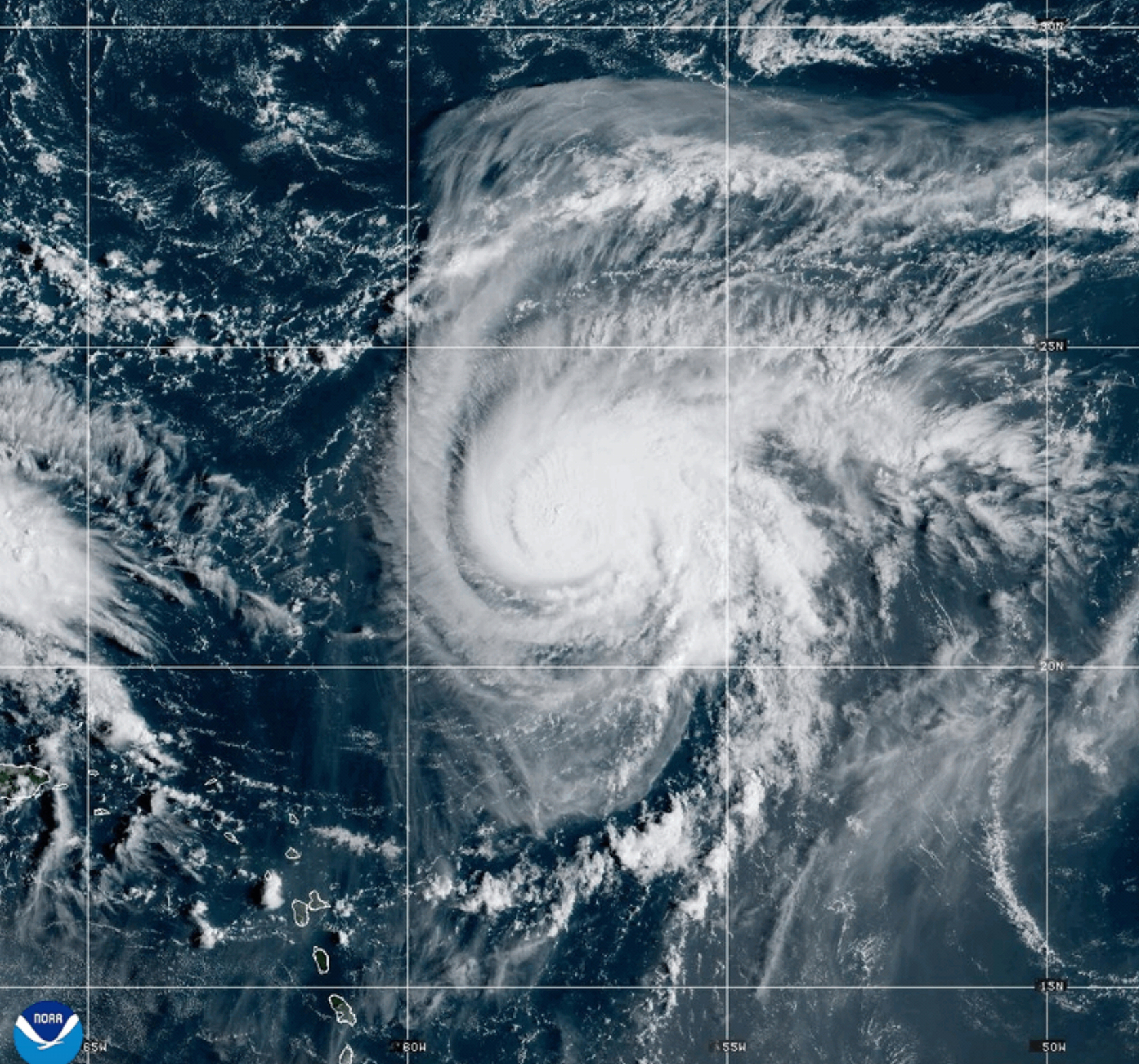
Enter Hurricane Humberto
While Imelda-to-be poses the immediate threat, Hurricane Humberto — already a major hurricane further east in the Atlantic — may become an unexpected shield. According to Brian McNoldy, a hurricane researcher at the University of Miami, Humberto’s position and strength could dictate multiple outcomes:
- Redirection: Humberto tugs Imelda eastward, pulling it out to sea.
- Disruption: Humberto’s stronger circulation tears Imelda apart.
- Merger: The two systems combine into a single, more powerful storm.
- Fujiwhara Effect: A rare “dance” where two cyclones orbit around each other.
McNoldy said the most likely outcome is the gentle redirection scenario, sparing the Carolinas from a direct impact. “I wish they were closer… it would fling future Imelda out to sea,” he said.
The Rare Fujiwhara Effect
One of the rarest possibilities, the Fujiwhara Effect, could see Humberto and Imelda-to-be spin around a shared center. This phenomenon, first identified over a century ago, occurs more frequently in the Pacific. The Atlantic saw a recent case in 2023 when Tropical Storms Philippe and Rina briefly orbited each other without reaching U.S. shores.
Currently, Humberto and Imelda remain about 1,100 miles apart. Interaction typically requires the storms to close to within 800 miles, Brennan noted, making the Fujiwhara scenario less likely.
Atmospheric Forces at Play
Humberto’s size and strength could also hinder Imelda’s growth. Ryan Torn, an atmospheric scientist at the State University of New York at Albany, explained that in hurricanes like Humberto, air rises at the core and then sinks at the edges. That sinking air may suppress Imelda’s development.
Given the unusual setup, the National Oceanic and Atmospheric Administration (NOAA) has deployed extra reconnaissance aircraft to gather data on the atmospheric corridor between the two storms. This added monitoring will help refine forecasts in what experts describe as a rare Atlantic storm scenario.
What’s Next for the Carolinas?
For now, the Carolinas remain at risk of flooding rains if Imelda strengthens and stays on track. However, the ultimate impact depends largely on Humberto’s westward motion. If the hurricane drifts closer, its circulation may weaken or redirect Imelda, reducing threats to the U.S. coast.
“This is a situation that doesn’t happen often in the Atlantic,” Torn said. “The natural spacing of storms usually prevents interactions like this.”
Until the picture becomes clearer, residents of the Carolinas are urged to monitor updates closely and prepare for potential rainfall hazards, even as hope builds that nature’s unusual “storm dance” might provide an unlikely shield.